Note: Since this article was first published, Fireball.International has rebranded and is now known as exci.
Imagine a system that could detect any bushfire in Australia within minutes of ignition so firefighters could tackle the blaze before it spreads.
Last week saw an important development on the road to this future: a Queensland-based company, Fireball, announced the first purpose-built satellite for fire detection in Australia.
Scheduled for launch a year from now, the satellite is the first of a planned constellation of 24 that will monitor Australia from low Earth orbit.
Once the full system, including ground-based cameras and aerial drones, is up and running, Fireball says it will be able to spot any fires within one minute of ignition.
That may sound like a bold claim, but it’s consistent with the goals of other organisations working on similar technology.
Within five years, experts say, we could have a national system of automated bushfire surveillance.
And we’ll need it, too. With climate change, the continent is drying out and the summers growing longer and hotter, and bushfires are predicted to become more frequent and intense.
Catastrophic bushfire seasons, like the 2019-20 Black Summer, will be inevitable.
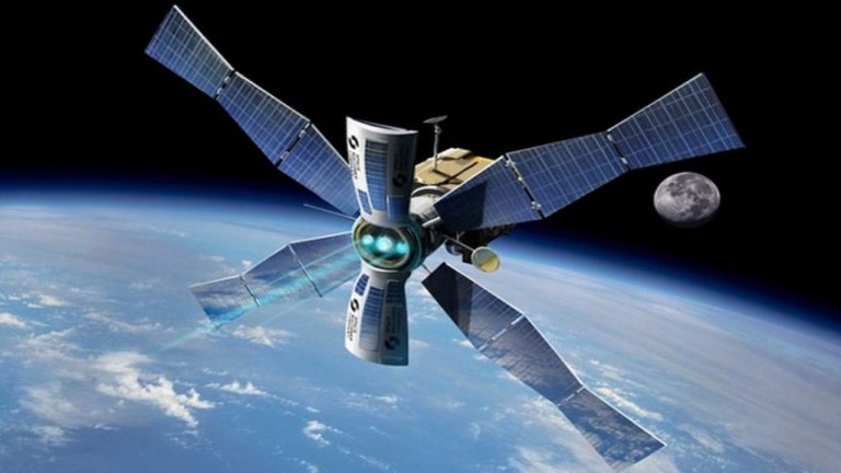 An artist’s impression of the Fireball satellite being delivered to its assigned position in orbit by a “space taxi”.(Supplied: Space Machines Company)
According to Marta Yebra, director of the Australian National University (ANU) Bushfire Initiative, advancements in satellites, drones and AI will drive big changes in firefighting.
At the same time, the challenges to making it happen are daunting.
A national system to detect fires in one minute one would produce vast amounts of data and require unprecedented cooperation between the patchwork of authorities and organisations.
The system would amount to automated surveillance of millions of square kilometres, accurate down to a few square metres and working non-stop all year.
How do we detect fires currently?
Though firefighting services have been trying new methods for detecting fires, most bushfires are still reported through triple-0.
There’s no reliable Australian data on the average time between ignition and detection (due to the difficulty of calculating ignition time), but a 2012 CSIRO experiment found an observer in a tower took about 30 minutes.
In remote places without observers, or at night, fires can burn for hours before they’re reported.
In effect, authorities sometimes don’t know about a fire until it’s too late to stop it, Dr Yebra said.
“Basically, most of the fires from the 2019-20 season were ignited by lightning in remote areas. At the moment, we are missing the small fires,” she said.
These small fires grow into big ones. The 2019-20 Gospers Mountain mega-fire that ended up burning half a million hectares over a period of months was traced back to a single lightning bolt.
An ANU study last year attempted to model the economic cost of not detecting fires early over the coming years, when bushfires are expected to grow more frequent and intense.
It found detecting and responding to both large and small fires within 30 minutes could save over $8 billion in destroyed property and fire-fighting costs over the next 30 years.
Algorithm often quicker than triple-Zero
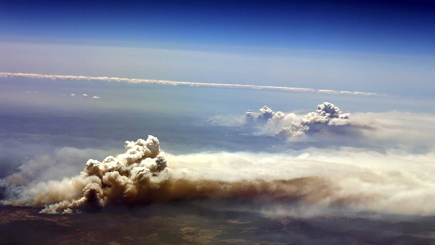
 An image of the NSW South Coast bushfires capture by a satellite orbiting in space in January last year.(Supplied: Copernicus Sentinel-2 satellite, ABC Perth.)[/caption]
During the Black Summer, an algorithm developed by RMIT used photos from the Japanese weather satellite Himawari 8 photos to detect new fires.
The detection system turned out to be blindingly quick.
It took the system about 60 seconds to process the satellite photos and sound an alert, said Simon Jones, a professor at RMIT’s Remote Sensing Research Group, who helped develop the algorithm.
However, the total detection time was longer than that, because Himawari 8 only takes one photo every 10 minutes and the data has to first travel through the Japanese meteorological service. Ultimately, there’s a minimum half-hour delay built into the system.
Also, fires smaller than a few football ovals might not be detected because the resolution of the satellite photo is only about 500 metres per pixel.
Still, RMIT’s algorithm was often quicker than the traditional ways of detecting fires.
A subsequent study found that 80 per cent of the system’s reports of new “hot spots” arrived faster than the triple-0 or other kinds of incident reports.
As well as being quick, the system worked day and night.
“The key diagnostic is that triple-0 and [state observers] rely on someone being up there and being present,” Professor Jones said.
“Whereas a satellite’s Earth observation is day and night and everywhere.”
Automated water gliders to the rescue
Although it may seem wildly ambitious, many experts say detecting fires within one minute anywhere in Australia is possible — and it could be done within five years to a decade.
ANU and Optus are developing a system of drone and ground-based cameras to automatically detect fires anywhere in south-eastern Australia.
They’re aiming to get the detection time down to one minute by 2025.
On top of this, the proposed system would extinguish newly detected fires in five minutes.
To reach this goal, ANU have proposed a system of automated water-bombing gliders that can zero-in on their target (eg. a lightning-struck tree) and drop a payload of water. If they get to the target quickly enough, not too much water is needed to extinguish the fire.
A C-130 cargo plane flying safely high above the fires could hold 30 of these gliders, Dr Yebra said.
“They provide very rapid response and high accuracy and control over the spread of the water — day and night,” she said.
Mining billionaire Andrew Forrest has also entered the fray. His Minderoo Foundation is working on an ambitious “Fire Shield” that, like ANU, would deploy automated firefighting machines to extinguish “dangerous blazes” anywhere on the continent within one hour.
Like ANU, its deadline is only a few years away, in 2025.
System already running in US
The Queensland-based company Fireball already has a system in the western states of the United States.
According to Fireball chief technology officer Tim Ball, this rapid detection time has changed the way fires were fought during the record-setting 2020 California fire season.
“In California, having this technology has changed the perspective of the fire services, because they fight fire much more aggressively,” he said.
“They’re not guessing at what’s out there.”
To detect fires from so far away, the Fireball system uses techniques developed to spot supernovae in distant galaxies.
In 1991, an astrophysicist at the University of California, Berkeley, Carl Pennypacker, witnessed a bushfire tear through his hillside neighbourhood.
He wondered if the type of satellite telescope he was using to detect bright spots a billion light years across the universe could be pointed back to Earth to detect a small fire.
The problem would be the same: filtering out background noise.
Twenty-two years later, in 2013, (after being part of Nobel Prize-winning research into the accelerating expansion of the universe), Professor Pennypacker and his team introduced the idea of using satellites and drones to snap images in the 3.9 micron band, a wavelength of light that fires emit but which is invisible to the human eye.
A computer would then spot the difference by subtracting recent photos from new ones of the same area.
Any new points of light in the 3.9 micron band would indicate a new ignition.
It worked. University of California patented the idea and Professor Pennypacker set up his own company, Fireball, that licenced the technology.
And then during the 2020 California fire season, Fireball’s automated system detected 850 fires.
“Carl’s idea was that we could see these tiny, tiny signals in a really noisy background at the edge of the cosmos,” Dr Ball said.
“And if you’re willing to make an aggressive attack on a tiny fire, it’s not going to spread.”
Can’t rely solely on automated systems: NSW RFS
However, in contrast to Fireball’s optimism, Australian fire services have expressed caution.
NSW RFS manager of predictive services, Laurence McCoy, said the service was in the “process of evaluating” using algorithms to automatically detect fires from satellite imagery, but he remained wary of too much automation.
“You can’t rely on these systems solely,” he said.
“You need people to interpret them.”
And aside from interpretation, he said, you also need someone “on the ground” to check if there’s a fire.
Of course, sending someone to check if the computer was right partly defeats the purpose of having automated detection.
Rural firefighting depends on volunteers, Mr McCoy said. Fire authorities need to be very certain they’re needed before sounding the alarm.
“We want to have confidence in our monitoring,” he said.
In a statement, QFES said it does not currently use satellite-based bushfire detection, “but is aware of companies developing these systems”.
Fireball, meanwhile, is not waiting for the authorities to get onboard.
It’s proceeding with a privatised model where the user pays for fire detection. It recently signed a deal with a Queensland plantation company.
“We are also looking into private companies, which have private firefighting forces,” Fireball chief executive officer Christopher Tylor said.
Fireball estimated its full constellation of 24 satellites would be ready within five years.
As well as these, it’s also looking into the possibility of launching a geostationary satellite, which would be much more expensive (Himawari 8 cost Japan about $1 billion to build and launch in 2014.)
In the meantime, it’s also building a network of ground-camera-only fire surveillance. It estimated this would cost $12.30 per square kilometre, which it said worked out to an annual per capita cost of $13 in WA or 50 cents in Victoria.
“Noosa Shire has 55,000 people living there. The cost of the system, including the installation, would be under $1 per person living there per year,” Mr Tylor said.
Will fire detection become privatised?
Fireball’s satellite launch announcement raises the question: Will Australians living in wealthy areas one day have better fire detection than those elsewhere?
Dr Yebra said she’s open to collaborating with Fireball on fire detection.
“Our hope is that at the ANU, we’re able to coordinate the different initiatives,” she said.
“I don’t think a single company can cover the whole of Australia.”
Australia doesn’t have any of its own satellites for detecting bushfires. Instead, in an emergency, authorities rely on the goodwill of Japan, Korea and the European Union, who share data from their own expensive weather satellites.
What if that good will runs out in the middle of a catastrophic fire season?
This is one of the questions currently being asked at the parliamentary inquiry into Australia’s space industry.
The NSW Government’s submission to the inquiry notes that “the devastating 2019 bushfires demonstrated the potential advantages of Australian-managed and owned satellites”.
And the Bureau of Meteorology’s submission says: “Access to data from foreign-owned satellites depends on the capacity of foreign meteorological services and may not always be assured.”
Dr Yebra said having Australian fire-detecting satellites was essential.
ANU plans to launch its own low Earth orbit satellite to map fuel loads and help determine bushfire risk, and is looking to raise $5 million to build the payload.
“I think the government needs to at least fund the research and development for the technology to be in a mature state,” she said.
“And then it’s the question of who is going to be maintaining the technology in the longer term.”
by technology reporter James Purtill/ABC Science
15 Mar 2021