
Satellites in Space play an important role in the environmental monitoring of our planet. By gathering data through advanced imaging technologies, environmental satellites provide us with invaluable insights into the health of our planet. One of the environmental satellites’ most important functions is providing crucial data to make accurate and life-saving weather predictions. This allows meteorologists to monitor storms around the globe, identify volcanic ash and track hurricane development. They can help us identify changes, patterns and trends and assess the environmental impacts of human activities. We have come a long way since the World Weather Watch (WWW) was established in 1963. Since the 1960s, we have sent different types of satellites into space to monitor Earth’s entire surface. We now have environmental satellites that are much more advanced, and scientists know how to use them much better. We are about to see an exciting new generation of environmental satellites.
In this first part of the series, we will explore the different types of environmental satellites, how they are used to protect our environment and the current configuration of the environmental satellite system.
For a start, check out this video created by the European Space Agency
Video: Space for Earth created by ESA
Types of Earth-Observing Satellites
Satellites orbit the Earth at different altitudes depending on what they have been designed to achieve. There are two main types of satellites:
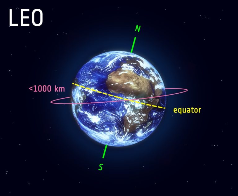
Low-Earth-Orbiting Satellites (LEOS)
LEOS circle at a low altitude close to the Earth’s surface. They can orbit as low as 160 km or as high as 2,000 km above Earth but usually fly at an altitude of less than 1,000 km. Because their plane can be tilted, they can fly different routes around Earth. Therefore they are most commonly used for satellite imaging because they can take images of higher resolution. It takes them approximately 90 to 120 minutes to circle Earth and complete 12 to 16 orbits per day. This makes them ideal for remote sensing missions, including Earth observation and reconnaissance. 55% of all operational satellites are in low earth orbit. It requires a constellation of hundreds to thousands of LEOS to provide connectivity for any given area.
Polar Orbiting Satellites (POES)
Polar-orbiting satellites are a type of LEO satellite passing over the Earth’s poles at a low altitude (typically 850 km) in a north-to-south (descending) or south-to-north (ascending) direction while the Earth rotates underneath. During the ascending pass, the satellite views the nighttime side of Earth and crosses back into daylight when it orbits in the descending direction. Polar-orbiting satellites complete 12-16 orbits per day, taking about 99 minutes to complete one full revolution. Therefore, they can observe the entire Earth’s surface within 24 hours twice – once in daylight and once in the nighttime.
Satellites in a sun-synchronous orbit (north to south or south to north) are also polar-orbiting satellites, but they are synchronised to the sun. This means that they are always in the same position relative to the sun; therefore, the satellites pass over any given point on Earth’s surface at the same local time. This allows scientists to analyse the data for weather patterns, predict weather or storms, and monitor wildfires or flooding. Data is only collected on the sunlit side of the Earth.
 Low Earth Orbit – Image by European Space Agency
Advantages of LEOS
- Because they are closer to the Earth’s surface, the time lag (latency) between the acquisition of data by a sensor and making it available is significantly lower than that of geostationary satellites (GEOS). The delay between sending and receiving a signal takes around 50 milliseconds for LEOS compared to about 560 ms for GEOS.
- LEOS provide more detailed images because the satellite orbits at a low altitude.
- Excellent views of the polar regions.
- Polar-orbiting satellites have a narrower field of view but much higher spatial resolution.
- The costs to build and send LEOS into orbit are much lower than that of GEOS.
- The signals are more accurate.
Disadvantages of LEOS
- You cannot see the entire surface of the Earth at once, as the satellite’s orbit changes due to the rotation of the Earth.
- This also means that no two images are from precisely the exact location.
- The satellite is only in the range of listening equipment for about six or seven hours a day, which limits the number of images that can be taken.
- LEOS must relay their data through other satellites in order to reach ground stations and polar-orbiting satellites, which experience significant signal attenuation as they pass over the Earth’s horizon.
- They have a greater orbital velocity
- Their lifespan is much shorter. LEO satellites have a lifetime of 7-10 years.
- Continuous temporal observation is not possible with a single satellite. However, satellites in Low Earth orbit are typically deployed as part of a satellite constellation because each individual satellite only covers a limited area that changes as the satellite moves rapidly to maintain its orbit.
- They are unable to give near real-time detections due to their high revisit times.
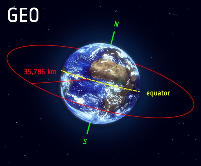
Geostationary Orbiting Satellites (GEOS)
Geostationary satellites (GEOS) orbit the Earth at a much higher altitude than LEOs at about 35,800 km (22,300 miles) above Earth’s equator at the speed and direction equal to Earth’s rotation, which means they maintain their positions at a fixed longitude, enabling them to provide frequent repeat full disk imagery every 5 – 15 minutes. Because they are in sync with the Earth’s rotation, the orbit takes 24 hours. However, typically they have coarser spatial resolution than satellites at a low altitude. They also fly at a much lower pace of about 3 km per second than LEOS because of their proximity to the Earth. A single geostationary satellite can see 42% of the earth’s surface, and a constellation of three equally spaced geostationary satellites can provide approximately 80% coverage of the Earth at once because they are limited to the curvature of the Earth.
 Geostationary orbit – Image by European Space Agency
Advantages of GEOS
- Satellites in geosynchronous orbit (GEO) are designed to last much longer than LEOS, typically around 15 years, and many continue to operate for 18 or more years.
- They have a full view of planet Earth at all times and can take pictures as frequently as once per minute.
- Because they observe from the same perspective, their recordings can be used to map patterns in global cloud movement over time.
- The satellite equipment also picks up transmissions sent from free-floating balloons, buoys and remote data collection stations around the globe.
- Their stationary position above the Earth’s surface allows for continuous monitoring of a specific region which is particularly useful for observing weather conditions and forecasting.
- They can cover large sections of Earth at once.
- They have much higher data transmission rates than their low-Earth and polar-orbiting counterparts because they can maintain a direct line of sight with ground stations on the Earth’s surface. For example, the time interval of Himawari-8 full-disk observations is 10 minutes in contrast to polar-orbiting satellites, which can take hours.
- They are less susceptible to atmospheric interference than their low-Earth and polar-orbiting counterparts. This is due to the fact that they are located above the Earth’s atmosphere, while low-Earth satellites must pass through the atmosphere on their way to and from orbit, and polar-orbiting satellites experience significant atmospheric drag as they circle the Earth.
- They have low orbital velocities.
Disadvantages of GEOS
- The high altitude of the geostationary orbit provides a lower detailed view as it is 35,000 km from Earth.
- The curvature of the Earth limits views of the polar regions. This means that they do not provide truly global coverage.
- Their stationary orbit makes them more susceptible to debris collisions than their low-Earth and polar-orbiting counterparts. This is because there is a greater concentration of debris in the geostationary orbit.
- They have a limited field of view. This is due to the fact that they are fixed in orbit and cannot move to track objects on the Earth’s surface. As a result, they can only image a small region of the Earth’s surface at any given time.
- Because GEO satellites orbit at such a high altitude, there is a significant delay in the data they collect and that data being received by ground stations. The delay between sending and receiving a signal takes around 50 milliseconds for LEOS compared to around 560 ms for GEOS.
- Geostationary satellites have a relatively low spatial resolution.
- They are more expensive to build and launch than their low-Earth and polar-orbiting counterparts. This is due to the fact that they require more precise orbits and larger antennas to maintain their stationary positions.
- Vulnerable to sun outages.
Configuration of the Global Environmental Satellite System
Global Earth Observation Satellite System – Image by BMO
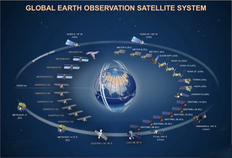 Global Earth Observation Satellite System – Image by BMO
The Geostationary Operational Environmental Satellites (GOES), operated by the National Oceanic and Atmospheric Administration (NOAA) of the United States, support weather forecasting, severe storm tracking, and meteorological research. The Polar Orbiting Environmental Satellites (POES), operated by both NOAA and the National Aeronautics and Space Administration (NASA) of the United States, provide global Earth Observation data for weather forecasting, climate research, and other applications.
The GOES and POES satellites carry a suite of advanced instruments that allow them to observe the Earth’s atmosphere, land, and ocean surfaces. These instruments include visible and infrared imagers, ultraviolet spectrometers, and microwave radiometers.
Instruments on Board of Polar-Orbiting Satellites
- POES satellites are equipped with the Moderate Resolution Imaging Spectroradiometer (MODIS) and the Visible Infrared Imaging Radiometer Suite (VIIRS). In addition to visible and near-infrared bands used for conventional RGB images, MODIS also has 36 other spectral bands spanning from the ultraviolet to the thermal infrared. The resulting wealth of data from these bands are used to characterise and monitor a large number of Earth processes, including vegetation index, aerosol-cloud cover, land surface temperature, etc. The data collected by VIIRS is used to expand upon the MODIS applications to fire and air quality monitoring, agriculture monitoring and production modelling, carbon modelling, and flood and sea ice mapping.
- The Cross-track Infrared Sounder (CrIS) and the Advanced Technology Microwave Sounder (ATMS) work together, providing global high-resolution temperature and moisture profiles. The Cross-track Infrared Sounder (CrIS) is a sounder that will provide vertical profiles of temperature and moisture in Earth’s atmosphere with unprecedented accuracy and resolution. The CrIS instrument has three spectral bands in the thermal infrared portion of the electromagnetic spectrum. The Advanced Technology Microwave Sounder (ATMS) is a 22-channel microwave sounder that will provide atmospheric temperature and moisture profiles and can be used to produce images inside storms, including hurricanes. The Ozone Mapping and Profiler Suite (OMPS) is a suite of three instruments that measure ozone concentrations in Earth’s atmosphere from the stratosphere to the troposphere. The Clouds and Earth’s Radiant Energy System (CERES) is a broadband radiometer that measures the energy emitted by Earth’s atmosphere and surface and produces a long-term record of global climate data, helping to understand of how Earth’s radiation budget varies in time.
Instruments on Board of Geostationary Satellites
- The GOES satellites are equipped with the Advanced Baseline Imager (ABI), a next-generation imaging instrument that provides high-resolution visible and infrared imagery of Earth’s atmosphere and surface. The ABI has 16 spectral channels, which allow it to observe a wide range of atmospheric and surface conditions. It scans the full disk every 10 minutes and provides coverage of the Continental United States (CONUS) every 5 minutes and images from both mesoscale domains every 60 seconds (or one sub-domain every 30 seconds). The data collected by the ABI is primarily used for major events such as hurricanes and thunderstorms and will infrequently monitor fires. However, ABI is a multi-purpose instrument of which fire detection is just one of many other applications.
Australia is currently covered by the geostationary HIMAWARI-8 and -9 satellites operated by the Japan Meteorological Agency (JMA). Both carry the Advanced Himawari Imager (AHI), an imaging instrument that provides high-resolution visible and infrared imagery of Earth’s atmosphere and surface. The AHI has 16 spectral channels, which allow it to observe a wide range of atmospheric and surface conditions. The data collected by the AHI supports weather watch, NWP (Numerical Weather Prediction) utilisation and environment monitoring, as well as wind derivation by tracking clouds and water vapour features. Australia also receives data from the polar-orbiting satellites TERRA, AQUA, NOAA-19, JPSS-1 (NOAA-20) and SUOMI-NPP.
The European Organisation for the Exploitation of Meteorological Satellites (EUMETSAT) operates a fleet of Meteosat satellites that provide coverage of Europe and the surrounding regions. The Meteosat series of satellites are geostationary (Meteosat-9, -10, and -11). Meteosat-11 carries the Spinning Enhanced Visible and Infrared Imager (SEVIRI), an imaging instrument that provides high-resolution visible and infrared imagery of Earth’s atmosphere and surface. The SEVIRI has 12 spectral channels, which allow it to observe a wide range of atmospheric and surface conditions. The data collected by SEVIRI are used to generate products providing, among other information, permanent data about the temperatures of clouds, land and sea surfaces. EUMETSAT also operates the polar-orbiting satellites Europe’s Metop-B and –C satellites, which continuously collect data from an altitude of 817 km to provide global data for weather forecasts. The second generation of Metop satellites (Metop-SG) is planned within the 2023-2043 timeframe and is composed of two series (Metop-SG A and B, each including three satellites.
China uses its satellites’ remote sensing data for civilian and military purposes. Therefore it is difficult to delineate between the two. However, the following is a non-exhaustive overview of China’s satellites that are also used for Earth observation.
The Feng Yun (FY) series of satellites covering Eastern Asia and Australasia include both geostationary satellites (FY-2 and FY-4) and polar-orbiting meteorological satellites (FY1, FY3). FY-4A carries the Advanced Geosynchronous Radiation Imager (AGRI), an imaging instrument that provides high-resolution visible and infrared imagery of Earth’s atmosphere and surface. The AGRI has 16 spectral channels tasked with providing all-weather real-time monitoring of atmospheric temperature, humidity, water vapour, cloud motion, wind field and other parameters over China as well as the surrounding areas. Weather satellites have significantly improved China’s meteorological observation and weather forecasting capability. They have also contributed to international weather cooperation and disaster prevention and relief. China also launched a series of Huanjing satellites for disaster and environmental monitoring that exploit the sun-synchronous orbit and are equipped with visible, infrared, and multi-spectral sensors and synthetic aperture radar (SAR). The program lifetime is 2008-2031.
The Chinese High-resolution Earth Observation System (CHEOS) is a space-based remote sensing system consisting of optical and synthetic aperture radar (SAR) satellites. The system is designed to provide high-resolution imagery of the Earth’s surface for a variety of applications, including disaster monitoring, land use mapping, and environmental protection.
CHEOS consists of two polar-orbiting satellite constellations: the Gaofen satellite constellation and the Hai Yang satellite constellation. The Gaofen satellite constellation is composed of optical satellites that provide high-resolution imagery to assist China’s maritime development, environmental resource monitoring, and disaster prevention and mitigation. The first satellite in the constellation, Gaofen-1, was launched in 2013. More than 25 Gaofen satellites have been launched since then.
The Hai Yang satellite constellation consists of four Hai Yang-1 and four Hai Yang-2 satellites to survey ocean resources and monitor the maritime environment. The first satellite in the constellation, HY-1, was launched in 2011. HY-3 will provide SAR observation, but it has not been launched yet. The Beijing series consists of three remote sensing satellites that have been built to provide information on agriculture, water resources, environment and disaster monitoring throughout China. The satellites exploit sun-synchronous orbits. The Jilin-1 satellite constellation captures high-definition optical and hyperspectral imagery. By 2030 the constellation should consist of 138 satellites to image the entire Earth’s surface every 10 minutes. Currently, over 60 satellites have been launched. Most of them are in sun-synchronous orbits.
The Russian Federal Service for Hydrometeorology and Environmental Monitoring currently operates the ELECTRO-L series in geostationary orbit to provide data about the Earth’s surface and atmosphere. The satellites of the METEOR-M series are polar-orbiting. Their instruments provide data for cloud cover mapping, Earth surface monitoring, and atmospheric temperature. The primary tasks of the satellites of the KANOPUS series are monitoring disasters, observing agriculture, water and coastal resources, mapping, and detecting forest fires and emissions of major pollutants in the environment.
Repeat cycle vs Revisiting time
As the Earth is rotating, LEO or polar orbiting satellites trace out a different path (ground track) in each subsequent orbit above the Earth’s surface after a defined number of revolutions until it retraces its path a second time over the same point on the Earth’s surface directly below the satellite, known as the nadir point. This time interval is often fixed when the remote sensing satellite is launched into special orbits, which is called the repeat cycle and varies with each satellite. The satellite covers nearly the entire Earth’s surface in a repeat cycle.
In contrast to the repeat cycle, the revisit time depends not only on the orbit but also on the satellite’s payload, such as the tilt angle, the target location and the sensor’s swath. The revisit time is the time interval between two successive satellite observations of the same spot on the Earth’s surface (off-nadir). Revisit requires a very close repeat of the ground trace. Because the viewing swath of the Moderate Resolution Imaging Spectroradiometer (MODIS) operating on the Terra and Aqua satellites is 2,330 km wide, their revisit period is one to two days. A satellite with a large swath can revisit the exact location more often. A satellite’s revisit time with a high inclination (orbit’s angle in relation to Earth’s equator) is longer for equatorial areas than for polar regions.
With polar orbits or highly inclined low Earth reconnaissance satellites specifically, the sensor also has variable swath capability to look sideways at targets (from east-west) rather than just observing them directly overhead. This means that most EO satellites have the ability to modify their orientation in space (attitude) to observe areas outside their ground track. The revisit time is less than the orbit cycle time because an area (off-nadir) can be viewed before and after the satellite passes over a target by using steerable sensors. Off-nadir refers to the angle at which a satellite is looking when it collects data. This angle can be off of the vertical or perpendicular to the Earth’s surface.
What is a swath?
The sensor on a satellite “sees” part of the Earth’s surface as it revolves around the planet. The area that is captured in an image is called a swath, which generally measures between tens and hundreds of kilometres wide. If the Earth didn’t rotate, the satellite would maintain its east-west position during orbit.
Even though it appears to be shifting westward when looking at it from Earth, this is because the Earth is rotating beneath the satellite (from west to east). Consequently, with each new pass, a different area becomes visible. The combination of the satellite’s orbit and the rotation of the Earth allows for full coverage of our planet’s surface until one cycle of orbits has been completed.
Swaths allow the user to get detailed information about an area without having to visit it physically. Satellites use swaths to map out an area. This data can then be used for a variety of applications, such as monitoring land use, tracking wildlife populations, and studying climate change. Swaths are also valuable for disaster management, as they allow emergency responders to quickly assess the extent of damage caused by fires or flooding. In the below image, a swath is revealed as the satellite passes over a location on the Earth, showing the measured precipitation data.
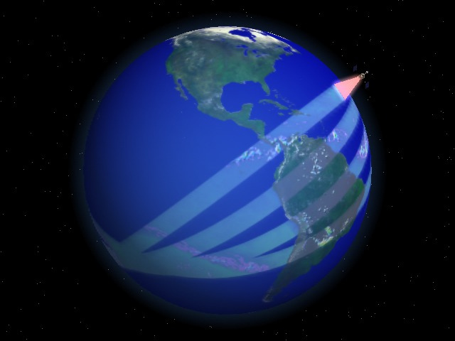
Image by NASA/Goddard Space Flight Center Scientific Visualization Studio

Polar Orbiting: Aqua Satellite and MODIS Swath – Image Credits: NOAA
What is data latency?
Anyone who plays games knows about the importance of ping (or latency), which is the time it takes (in milliseconds) for data to travel from one point to another. A ping rate of over 150 milliseconds (ms) will affect gameplay. The latency (the delay between sending and receiving a signal) on GEO satellites is at around 560 ms as a result of the much greater distance involved, compared to around 50 ms for LEOs. However, in satellite imagery, NASA defines data latency as the time it takes for a satellite image to be acquired and processed after a satellite has passed over an area (total latency). While the data is transferred in milliseconds, the time it takes to process it can take hours.
This processing time can be affected by many factors, such as cloud cover, whether the satellite is within range of a groundstation, and the distance between the satellite and the ground. Most satellite imagery providers offer high latency access, which means customers have to wait up to a week after placing an order before receiving usable imagery. This can be problematic for people who need timely information.
Data latency can be a significant issue for those who rely on satellite imagery for mapping or other purposes. Swaths and data latency are crucial factors when working with satellite imagery. Environmental satellites have revolutionised our understanding of the environment, but it is also essential to understand their limitations.
Satellites started to change the World
The future of environmental satellites started when a few people at the end of World War II realised that space flight was now achievable. While the idea of spaceships became a definite possibility, it was viewed as an exclusive Air Force domain. This changed in 1958 when the United States launched the weather satellite Vanguard-1 in response to the Soviet Union’s first satellite, Sputnik 1. Read more about the history of environmental Satellites in Part 2.
Read more:
by Gabrielle Tylor
exci – The Smoke Alarm for the Bush
Early Bush/Wildfire Detection and Notification Service
27 November 2022