Satellites have been used for weather observation and forecasting since the late 1950s. The first weather satellites were military, used for reconnaissance and intelligence gathering. However, in the early 1960s, it was recognised that satellites could also be used for civilian purposes, such as weather forecasting and storm tracking.
The first proposal for a non-military satellite was made in 1946 by the National Academy of Sciences in Washington, DC, at a conference to an international audience including Australia, Britain, Canada, France, Japan, the former Soviet Union, and the United States. However, the technology at the time was not advanced enough to make this idea a reality.
Polar-orbiting Satellites
In 1957, the former Soviet Union launched the first satellite, Sputnik 1, using a military intercontinental ballistic missile and sparking a space race between the United States and Russia. To the scientist’s disappointment, they did not have access to its design or orbital elements.
The U.S. Department of Defence responded by launching its first satellite, Vanguard-1, in 1958. This satellite measured cosmic rays. Later that same year, the first weather satellite (Vanguard-2) was successfully placed in orbit to measure cloud cover distribution and provide information about atmospheric density. The satellite had a projected orbit lifetime of 300 years. However, the data of the optical instrument was of poor quality due to the technology of the time, and therefore it re-entered Earth’s atmosphere after only two years.
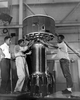
On April 1, 1960, the first dedicated weather satellite capable of remote sensing of the Earth, known as TIROS-1, was launched. The satellite was polar orbiting, meaning it passed over Earth’s north and south poles. TIROS-1 was equipped with two cameras and two video recorders that took pictures of cloud formations and transmitted them back to Earth twice a day, but covered only the tropics and mid-latitudes. For the first time, it was possible to identify developing storms from orbit from the satellite’s large-scale cloud patterns. For example, the satellite provided continuous observations of a developing storm off the coast of Bermuda over four days, allowing for tracking the cyclonic mass as it dispersed.
Although TIROS-1 was only operational for 78 days, NASA’s first experimental step to use satellites for weather forecasting proved the usefulness of satellite weather observation and paved the way for the NIMBUS program. Between 1964 and 1978, NASA launched seven Nimbus satellites. The last one was launched in 1978 and decayed in 1994. The satellites were all equipped with cameras that took pictures of Earth’s weather patterns. One of the most significant achievements of the Nimbus program was the development of weather forecasting models. These models used data from weather satellites to predict weather patterns. The Technology, which NASA later transferred to the National Oceanic and Atmospheric Administration (NOAA), formed the basis of most earth-observing satellites NASA and NOAA have launched.
The TIROS Program eventually led to the initiation of the Environmental Science Services Administration Satellite Program (ESSA). For four years, the ESSA satellites sent thousands of images back to Earth, which allowed ground stations to predict weather patterns. By 1970, ESSA was reorganised as NOAA. The last satellite of this program was ESSA-9 which was 1,726 days operational until it was deactivated in 1972.
The Terra satellite, EOS AM-1, is the flagship of NASA’s Earth Observing System (EOS), comprising a series of satellite missions and scientific instruments in Earth orbit. The satellite was launched in December 1999 with five different instruments on board, one of which was the MODIS (Moderate Resolution Imaging Spectroradiometer). In addition to visible and near-infrared bands used for conventional RGB images, MODIS also has 36 other spectral bands spanning from the ultraviolet to the thermal infrared. The resulting wealth of data from these bands is used to characterise and monitor a large number of Earth processes, including vegetation index, aerosol-cloud cover, land surface temperature, etc.
The Aqua satellite, EOS PM-1, was launched in May 2002 with six different instruments on board, one of which was also the MODIS instrument. Aqua is the Latin word for water, bringing insight into our Earth’s water system.
Terra and Aqua are Low-Earth Orbiting (LEO) satellites, collecting data at an altitude of 705 km. Terra’s altitude has been lowered to 698 km in October 2022 to reduce the number of close approaches with other missions. Terra and Aqua have a far-reaching swath of 2,330 km. Therefore, MODIS needs 1-2 days to view the entire surface of the Earth (depending on weather conditions) at a spatial resolution of about 1 km.
Terra and Aqua are Low-Earth Orbiting (LEO) satellites, collecting data at an altitude of 705 km. Terra’s altitude has been lowered to 698 km in October 2022 to reduce the number of close approaches with other missions. Terra and Aqua have a far-reaching swath of 2,330 km. Therefore, MODIS needs 1-2 days to view the entire surface of the Earth (depending on weather conditions) at a spatial resolution of about 1 km.
While Terra moves around the Earth from north to south across the equator (descending), Aqua circles from south to north (ascending), resulting in global coverage every 1 to 2 days. Each satellite completes 14 orbits per day, taking about 99 minutes to complete one orbit. Data is only collected on the sunlit side of the Earth.
An Introduction to Aqua satellite – Credits: NASA/Goddard Space Flight Center
The Suomi NPP mission, operated by NOAA and owned by NASA, was launched in 2011, carrying the first Visible Infrared Imaging Radiometer Suite (VIIRS). This new instrument provides global observations of Earth’s land, ocean, and atmosphere with a high spatial resolution (750m at nadir) and 16 spectral bands. These characteristics allow for significant improvements in weather forecast accuracy. The data from VIIRS is also used to produce long-term climate records Joint Polar Satellite System (JPSS) is the National Oceanic and Atmospheric Administration’s (NOAA) next-generation polar-orbiting operational environmental satellite system. JPSS will provide global environmental data needed to understand our planet’s weather, climate, and oceans.
The below image of Asia and Australia at night has been mapped over existing Blue Marble imagery of Earth, using the satellites new “day-night band” of VIIRS. The filtering techniques of VIIRS enabled the removal of all forms of dim signals such as auroras, fires, and other stray light to emphasise the city lights. It has been collected by the Suomi NPP satellite in April and October 2012.
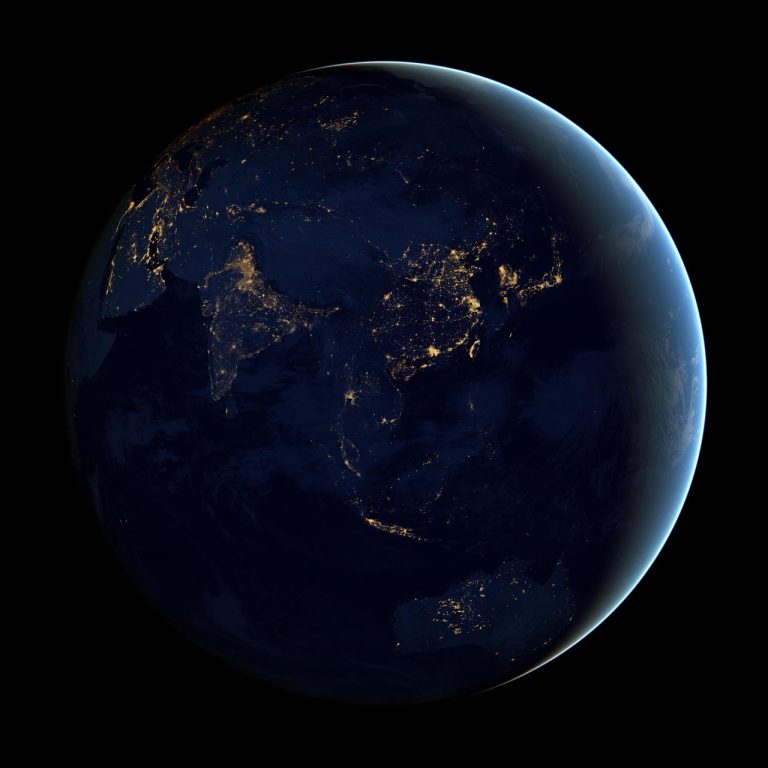 Black Marble – Asia and Australia – Credits: NASA Goddard
The first JPSS satellite, JPSS-1, was launched on November 18, 2017. The second satellite in the series, JPSS-2, is scheduled to launch in 2022. These satellites will carry advanced technology instruments that will make more precise observations of Earth’s weather and environment than ever before possible. Data from JPSS will enable weather forecasters to provide earlier and more accurate warnings for weather events like hurricanes, severe storms, and winter weather months in advance.
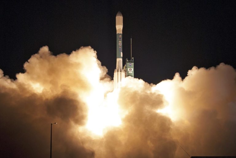 Delta II JPSS-1 Liftoff – Credits: NASA/Kim Shiflett
Because of NOAA’S plans to discontinue the morning orbit of the K, L, and M TIROS series, Europe consequently decided to develop and procure three MetOp satellites which formed the Eumetsat Polar System (EPS). The European contribution to the Initial Joint Polar Satellite System (IJPS) was a cooperative effort between NOAA and the European Organisation for the Exploitation of Meteorological Satellites (EUMETSAT), including 30 European Member States. MetOp-A was launched in 2006, followed by MetOpB in 2012 and MetOp-C in 2018. The polar-orbiting operational meteorological system provides data within 2 hours and 15 minutes of the measurements being taken, enabling global weather prediction and enhancing the understanding of climate change.
In 2020, India launched its first Earth observation satellite. EOS-01, carrying a synthetic aperture radar, followed by EOS-04 in February 2022, which was launched into the sun-synchronous orbit to provide high-quality images for agriculture, forestry, and flood mapping. Additional radar imaging satellites (RISAT-2, -2B and 2BR1) have been sent to low earth orbit. Their primary mission is to conduct reconnaissance and manage disasters. In 1999, ISRO launched the OceanSat program. As the name implies, its main mission was to observe the ocean. OceanSat-1 served 11 years, although it was initially built for a lifespan of 5 years. OceanSat-2 is still operational. The ResourceSat series satellites are advanced remote sensing satellites providing data to help monitor landscape changes. The Carto-Sat series is a part of the Indian Remote Sensing Program and is used for Earth’s resource management and monitoring (CartoSat-2A, -2B, -2C, -2D, -2E, -2F, and CartoSat-3).
Geostationary Satellites
NASA’s Applications Technology Satellite (ATS) venture initiated NOAA’s GOES program in 1966. The main goals were to test whether gravity would keep the satellite at a synchronous orbit 35,800 km (22,300 miles) above Earth’s equator at speeds equal to Earth’s rotation, which means the satellite would maintain its position and provide continuous coverage. In the early 1970s, NOAA, in collaboration with NASA, began to develop the Geostationary Operational Environmental Satellites. In 1974, the Synchronous Meteorological Satellite (SMS-1) was launched as the first weather satellite to use geostationary orbit. In 1974, the Synchronous Meteorological Satellite (SMS-1) was launched as the first weather satellite to use geostationary orbit. Monitoring broad areas of Earth continuously, the satellite obtained both day and night data while collecting and relaying information from over 10,000 central ground stations. The SMS-1 was quickly followed by other weather satellites in geostationary orbit, including the GOES series (Geostationary Operational Environmental Satellites).
In October 1975, GOES-1 went operational. In 1994, a significantly improved spacecraft, the GOES I-M series, was introduced. It carried an imager and sounder that operated at the same time but with independent instruments. This allowed for uninterrupted data collection of both imaging and sounding information and higher-resolution images. The search and rescue system also became operational with the GOES-8 satellite.
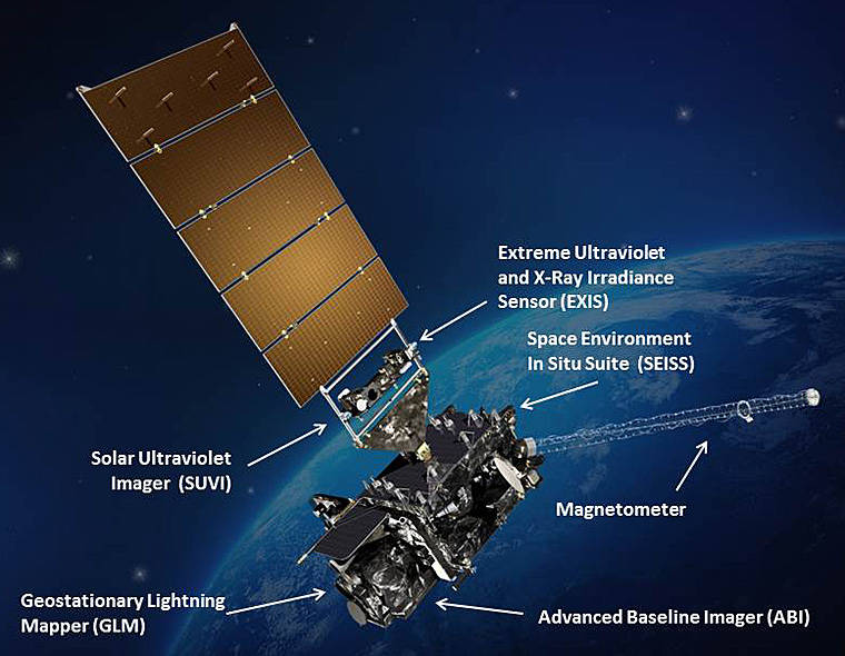
In November 2016, the first satellite of the geostationary GOES-R series was launched. The GOES-R series (also referred to as GOES-16 or GOES-East) of weather satellites are operated by the United States National Oceanic and Atmospheric Administration (NOAA).
The GOES-R series satellites are designed to improve the accuracy and timeliness of weather forecasts by providing more frequent and higher-resolution images of Earth’s atmosphere and surface. These types of satellites are the most advanced weather satellites ever built, and their images and data are used by forecasters around the world to help make life-saving decisions every day. The satellites also carry instruments that measure the atmospheric conditions that lead to severe weather events such as tornadoes, hurricanes, and flash floods.
 GOES-R with Earth in the background – Credits: NASA
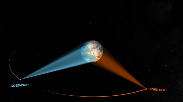
The GOES-R series is a four-satellite program: Currently, GOES-16 (GOES-East), GOES-17 (GOES-West), and GOES-18 (launched in 2022) are operating to improve the detection and observation of environmental phenomena. GOES-16 is currently stationed at 75° West longitude, providing coverage of the United States, Central America, and the Caribbean. GOES-17 was launched in May 2018 and is currently stationed at 137° West longitude, providing coverage of the Pacific Ocean region. GOES-18 was launched in March 2022 and is currently stationed at 128.2° West longitude, providing the Indian Ocean region coverage. The fourth satellite, GOES-19 is planned for launch in 2024. GOES-East (GOES-16) and GOES-West (GOES-17). These satellites provide higher-resolution images of weather systems than any other weather satellites currently in operation.
NOAA’s GOES-R series satellites are helping to revolutionise weather forecasting by providing more accurate and timely information about the changing Earth’s atmosphere and surface conditions. The satellite data and images are used daily by forecasters worldwide to help make life-saving decisions.
Several nations joined the geostationary orbit after the Americans launched GOES-1. In 2011, Russia launched the geostationary satellite Elektro-L No.1, which operates over the Indian Ocean. In 2014, the Japanese positioned Himawari-8 and two years later Himawari-9 over the East Asia, Japan and West Pacific region to provide typhoon, rainstorm and weather forecasting. The Europeans have operated the Meteosat series since 1977 to detect fast-developing severe weather, weather forecasting and climate monitoring.
The geostationary satellites operated by the China Meteorological Administration Administration (CMA) are the Fengyun 2 and 4 series (FY-2, FY-4). The primary purpose of the Fengyun series satellites is to provide meteorological data in support of weather forecasting and climate research. The satellites carry a variety of payloads, including visible and infrared imagers, atmospheric sounders, and space environment monitors. The Feng Yun 2A satellite was launched in 1998. FY-4A was launched in 2016 and is still operating.
The Indian Geostationary Meteorological Satellite (IGS) series is a set of weather satellites operated by the Indian Space Research Organisation (ISRO). Indian’s Meteorology branch started in 1982 with the launch of the INSAT-1 series. As of 2022, twelve satellites have been launched into the geostationary orbit, of which INSAT-3D and INSAT-3DR are still operational. The primary purpose of the INSAT satellites is cloud observation. They are also used for monitoring weather patterns and cyclones and providing data on climate change.
Urgent Action is needed to combat Climate Change
Climate change is one of the biggest challenges of our times. It affects every region of our home Earth and the future of our children and grandchildren. Satellite technology has the potential, together with other innovative solutions such as Artificial Intelligence, to ensure a sustainable future. However, time is of the essence; we need to act fast! There is an urgent need for rapid and resilient crisis response to save lives and protect our environment. While satellites are crucial for monitoring and understanding the environment as well as modelling and predicting the future of climate, early detection of disasters such as wildfires is not one of their strengths.
Want to know why?
Read more in
Check also out:
Part 1: Satellites in Space – Watching over our Planet
Part 3: Satellites Limitations in Early Wildfire Detection
Part 4: Early Wildfire detection=AI+Cameras+Satellites
by Gabrielle Tylor
exci – Smoke Alarm for the Bush
Early Bushfire/Wildfire Detection Technology
1 December 2022