Reality vs. Expectation in Satellite Wildfire Detection
As climate change worsens, the frequency and intensity of wildfires are rising, intensifying the need for quick and reliable detection systems. Over the past decade, satellite technology has evolved, offering valuable data to monitor environmental changes. But how effective are satellites in detecting wildfires, especially in the critical moments right after ignition? And what does “early detection” really mean?
Despite the impressive progress, satellite technology still faces significant hurdles in providing the rapid detection required to prevent small fires from growing into devastating disasters.
In this updated blog post, we will explore the current capabilities of satellite wildfire detection. We compare these with exci’s AI-powered early wildfire detection system using ground-based cameras to detect fires within minutes of ignition. Finally, we discuss why differences matter for ensuring rapid and effective emergency response.
Real-Time Data Limitations and New Developments
True “real-time” satellite data where information is available immediately after detection remains out of reach. For example, NASA’s Earth Observing System Data and Information System (EOSDIS) defines “real-time” data as being available within 60 minutes of a satellite’s overpass.
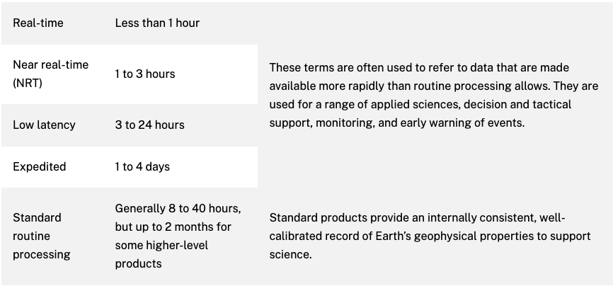 Terms for latency defined and agreed upon by participants across NASA for all data managed by EOSDIS
However, in 2022, NASA’s Fire Information for Resource Management System (FIRMS) introduced ultra-real-time data (URT). URT data is processed within 60 seconds of observation and made publicly accessible. This system, funded by NASA’s WildFireSense program, uses direct broadcasts from satellites and ground stations. The data is streamed in real-time, allowing users to view it on FIRMS maps, download it, or access it via map services like WMS and WFS. However, after six hours, the URT data is replaced by Near Real-Time (NRT) data, which arrives within three hours.
This development offers exciting possibilities for wildfire monitoring, aligning with NASA’s commitment to open-access scientific data. It supports a variety of users, including government agencies, researchers, and private entities, in managing wildfires.
Nevertheless, the system still faces several limitations:
- Coverage: URT data is only available for the continental U.S. (CONUS)
- Timing: Satellite detection relies on the satellite being overhead at the right time, which is rare. Wildfires can grow significantly before detection occurs.
- Processing Delays: Despite efforts to reduce latency, critical fire details may still be missed due to delays in processing, particularly in high-risk areas with frequent wildfires.
Geostationary Satellites: Fast, But Not Fast Enough
Geostationary satellites (GEOs), such as NOAA’s GOES-16 and Japan’s Himawari-8 monitor large areas continuously. They provide updates approximately every 10 minutes, which makes them helpful in detecting significant wildfires early. However, processing the images and sending alerts can range from 30 minutes to two hours.
The process begins when the satellites capture images and transmit the data to ground stations. This takes only a few minutes. After that, the images undergo pre-processing to remove cloud cover and atmospheric interference. Then, fire detection algorithms, like the BRIGHT system, analyze heat signatures from potential hotspots. Depending on the data complexity and system capabilities, this step can take several minutes to an hour. Once a fire is detected, notifications are sent to emergency responders. However, the total time from detection to alert is typically between 30 minutes to two hours.
Despite advancements like BRIGHT, a satellite algorithm which delivered fire hotspot data every 10 minutes, GEO satellites still face challenges. Their lower resolution limits their ability to detect small or emerging fires, especially those with dimmer heat signatures. While effective for large fires, the technology struggles with smaller ones. To ensure more reliable and widespread use, further advancements are necessary.
 Areas of the Earth viewed by GOES-East and GOES-West from 22,236 miles above the equator – Credits: NASA
Low-Earth Orbit Satellites: Better Resolution, But Slower Response
LEO (Low Earth Orbit) satellites provide higher-resolution images than GEO satellites, making them more effective at detecting smaller fires in their early stages. However, LEO satellites face challenges. Their longer revisit times, ranging from hours to days, limit their ability to trigger immediate response efforts. For example, satellites like Landsat-8/-9, Sentinel-2, and WorldView-3 can detect active fires with spatial resolutions between 20 m and 30 m, but their revisit times hinder early fire detection. Sentinel-2 revisits every five days, while Landsat-8/-9 takes up to eight days.
To achieve continuous global coverage, an extensive LEO satellite network is required. This demands careful planning and significant capital investment. The costs of deploying and maintaining LEO satellites—covering manufacturing, launch services, and ground stations—are high. Moreover, LEO satellites have shorter lifespans, requiring more frequent replacements than their GEO counterparts.
Emerging satellite networks aim to improve revisit frequencies by deploying larger constellations of smaller satellites. These advancements could enable near real-time wildfire monitoring. However, achieving consistent global coverage still requires multiple satellite passes, and data processing can introduce delays. Managing these large constellations also demands advanced network management systems. While AI and machine learning accelerate data processing, achieving continuous, large-scale global coverage remains a significant challenge.
 Low Earth Orbit – Image by European Space Agency
The Challenge of Heat Detection
Satellite sensors detect fires by identifying heat signatures that exceed the surrounding temperature. Larger fires are easier to detect, while smaller fires, especially those hidden beneath tree canopies or in dense vegetation, can be too subtle to distinguish from background noise. Detection accuracy is further affected by factors like fire intensity, smoke, and cloud cover. While sensors like Shortwave Infrared (SWIR) can penetrate clouds, smoke and low-intensity fires still pose significant challenges. Smouldering fires may produce heat signatures too weak for detection, and smoke can block thermal signals, making it difficult to pinpoint fire location and size. As a result, many small fires, especially those in hard-to-reach areas, often go undetected.
Wildfires – Credits: Urs Schopfer via flickr.com
False Positives
False positives present another significant challenge. Satellite systems frequently misidentify non-fire heat sources, such as oil fires, urban heat islands, or sun-heated surfaces, especially in areas with high human activity. Moreover, the large pixel size of many satellite sensors can make it difficult to detect small or low-intensity fires, especially in areas like grasslands. These fires might not generate enough heat to trigger a single pixel, requiring them to cover a larger area before being detected. Even higher-resolution satellites like VIIRS (375 m pixels) are constrained by these challenges, resulting in significant gaps in real-time detection.
Global Disparities in Data Accessibility
An estimated 10,000 satellites currently orbit Earth, with SpaceX’s Starlink constellation accounting for about 60%, and planning to expand to up to 40,000 satellites.While many satellites support communication and commercial activities, only a small number focus on scientific purposes like wildfire monitoring.
A few countries, including the United States, China, India, Japan, and the European Union, operate satellite systems with advanced hotspot detection algorithms. Notable systems like NASA’s MODIS, NOAA’s VIIRS, and the EU’s Meteosat program offer crucial fire-monitoring data for free. This ensures that fire agencies worldwide, even those without resources to develop their own systems, can access vital wildfire detection services.
Despite these efforts, international collaboration on satellite data remains fragmented. Many countries are still developing or refining their fire detection systems, leading to disparities in the quality and timeliness of data available to first responders.
The Critical Need for Speed
Satellite technology plays a key role in monitoring, understanding, and addressing climate change and its challenges, including extreme wildfire events. However, designing satellites involves trade-offs that limit their ability to detect wildfires early. This delay in detection is critical, as the time from ignition to containment depends on rapid response. Every minute counts.
Fires can spread with alarming speed—up to 25 kilometres per hour under dry conditions, strong winds, and abundant fuel. Early detection can mean the difference between a quickly extinguished fire and one that escalates into a disaster.
Despite its importance, the market for satellite-enabled wildfire services will remain a small segment of the broader Earth observation sector. While the Earth observation market is projected to grow from $3.5 billion to $8.8 billion over the next decade, infrared and thermal imaging services are expected to grow from $34 million in 2020 to $1.5 billion by 2030, according to Northern Sky Research senior analyst Prachi Kawade.
Google’s FireSAT Initiative: Promising, But Not Ready
The most significant recent development in satellite-based wildfire detection is the FireSat project. This initiative, spearheaded by the Earth Fire Alliance and supported by philanthropic organisations, including Google, aims to deploy a satellite constellation optimized for wildfire detection.
The first phase, launching in 2026, will feature three Muon Halo™ satellites equipped with advanced 6-band multispectral infrared sensors. These sensors are designed to detect small-scale fires, and with AI, FireSAT will compare areas as small as 5×5 meters with previous imagery to identify real wildfires and avoid false positives. The full FireSAT constellation, once complete, will comprise 50 satellites, providing global coverage and significantly reducing revisit times. The constellation aims for 20-minute revisits for most of the globe, with high-risk areas like wildfire-prone zones being revisited as frequently as every 9 minutes.
However, covering the entire Earth with only 50 low-Earth orbit (LEO) satellites and achieving a 20-minute revisit time is ambitious but theoretically possible under specific conditions. Nevertheless, there are several operational challenges:
- Data Processing and Latency: Even with advanced AI, processing and analyzing data from 50 satellites can introduce latency, which is a major concern for emergency responders.
- Hardware and Operational Costs: Maintaining a global satellite network with high revisit times requires a substantial investment in infrastructure, which could be a barrier to widespread adoption.
While FireSAT represents an ambitious leap forward in satellite-based wildfire detection, its inherent challenges highlight the need for complementary solutions that provide faster, more localised response capabilities. This is where exci’s AI-powered wildfire detection technology, leveraging ground-based cameras, demonstrates its unparalleled effectiveness in detecting fires at their earliest stages.
Ground-Based Cameras + AI: A Faster Solution
Satellite technology is vital for global wildfire monitoring, but exci’s AI-powered early wildfire detection system, using ground-based cameras, provides faster and more accurate results. These cameras capture high-resolution images, which exci’s advanced AI analyses to detect smoke within minutes of ignition. This rapid detection enables early intervention, helping to minimize potential damage.
Ground-based systems offer several advantages over satellites:
- Real-Time Detection: Cameras capture images every few seconds, enabling near-instant fire detection, even in its earliest stages.
- Higher Accuracy: AI-driven analysis ensures exceptional precision in detecting smoke or thermal anomalies.
- Reduced Latency: Ground-based systems provide immediate feedback, eliminating the delays inherent in satellite data processing.
exci’s AI-driven bushfire detection solution combines ground-based cameras with geostationary and polar-orbiting satellite imagery, enhancing both speed and coverage. Ground-based cameras excel in daytime detection, capturing smoke and fire within minutes, while satellites offer reliable nighttime detection and continuous monitoring, especially in remote areas. By integrating both technologies, exci ensures comprehensive wildfire detection with unmatched speed and accuracy.
 exci’s AI-Wildfire Detection Technology = AI+Cameras+Satellites
Key Developments (2022–2024)
Ultra-Real-Time (URT) Data from NASA’s FIRMS
- Launch of URT Data: NASA’s Fire Information for Resource Management System (FIRMS) began providing ultra-real-time data (URT) in 2022, processing data from MODIS and VIIRS within 60 seconds of satellite overpass.
- Faster Data Processing: This development dramatically reduced the time delay for detecting fires from satellite data, offering more timely information for fire management and response.
Increased Global Satellite Coverage:
Advances in satellite constellations, such as FireSAT (Google’s collaboration with Muon Space and the Environmental Defense Fund), have aimed to increase coverage and improve detection of smaller fires. FireSAT plans to deploy satellites equipped with advanced infrared sensors by 2026 to detect fires as small as 5×5 meters.
Enhanced Sensors for Fire Detection:
New sensors like SWIR (Shortwave Infrared) and improved thermal imaging capabilities have enhanced fire detection accuracy, even through some cloud cover and smoke.
Ongoing Challenges in Wildfire Detection
Timing and Satellite Overpass Limitations
- Satellite Overpasses: Wildfire detection through satellites is highly dependent on the timing of their overpasses. This is a rare event, and often, by the time a satellite detects a fire, it may have already grown significantly, limiting its effectiveness in early detection.
- Revisit Time: Satellites typically have long revisit intervals, ranging from several hours to days, which can delay detection and reduce the timeliness of responses.
Limited Ultra-Real-Time Data Coverage - Geographic Restrictions: Currently, NASA’s FIRMS provides ultra-real-time data primarily for the continental U.S., meaning large portions of the globe lack access to this rapid detection system, leaving wildfire-prone regions underserved.
False Positives and Detection Accuracy
Satellites like MODIS and VIIRS can detect false positives due to thermal signals from non-fire sources, such as urban heat, complicating the identification of true fire locations. Additionally, low-intensity or small fires, particularly in grasslands or forests, can be challenging to detect due to the broad pixel resolution of satellite sensors.
Challenges in Global Data Access
While certain countries, including the U.S., offer free access to satellite data, others have restrictions, making it difficult for many regions to access critical wildfire detection information in real-time.
Cloud Cover and Smoke Interference
Despite advancements in infrared technology, satellite detection is still vulnerable to weather conditions, such as cloud cover or thick smoke, which can obscure fire signals and reduce detection effectiveness.
Latency in Response
Although satellite data processing and transmission have improved, the inherent delays in these processes mean that satellite-based systems are still slower in providing timely alerts.
Conclusion
Over the past two years, satellite technology has made notable strides, such as Google’s FireSat initiative, which aims to enhance global fire detection capabilities. However, the effectiveness of such initiatives remains to be proven, particularly in addressing the fundamental challenges of satellite-based systems. These include limited timing due to infrequent revisit rates, constrained coverage areas, susceptibility to cloud cover, and difficulty detecting smaller or low-intensity fires—especially in densely vegetated or complex terrains. Revisit time, in particular, is a critical limitation; a satellite must pass over a fire at the right moment to detect it, which can result in delayed identification of rapidly spreading fires.
In contrast, exci’s AI-driven bushfire detection system, leveraging ground-based cameras, delivers faster and more immediate alerts to emergency responders by detecting fires within minutes of ignition. This real-time detection offers a crucial advantage over satellite-based methods, which often face delays due to long revisit times and limited coverage. By deploying cameras in strategic locations, exci’s technology ensures that forest fires are detected quickly, enabling swift responses and significantly reducing potential damage. This rapid detection, in conjunction with satellite data analysis, forms a comprehensive solution for wildfire monitoring, improving overall response time and effectiveness in fire management.
Want to know more?
Check out the following blog articles:
Part 1: Satellites in Space: Watching over our Planet
Part 2: History of Environmental Satellites
Part 4: Early Wildfire Detection = AI+Cameras+Satellites
by Gabrielle Tylor
exci – The Smoke Alarm for the Bush
AI-powered Early Bushfire/Wildfire Detection Technology
4 December 2022
Updated on 20 November 2024